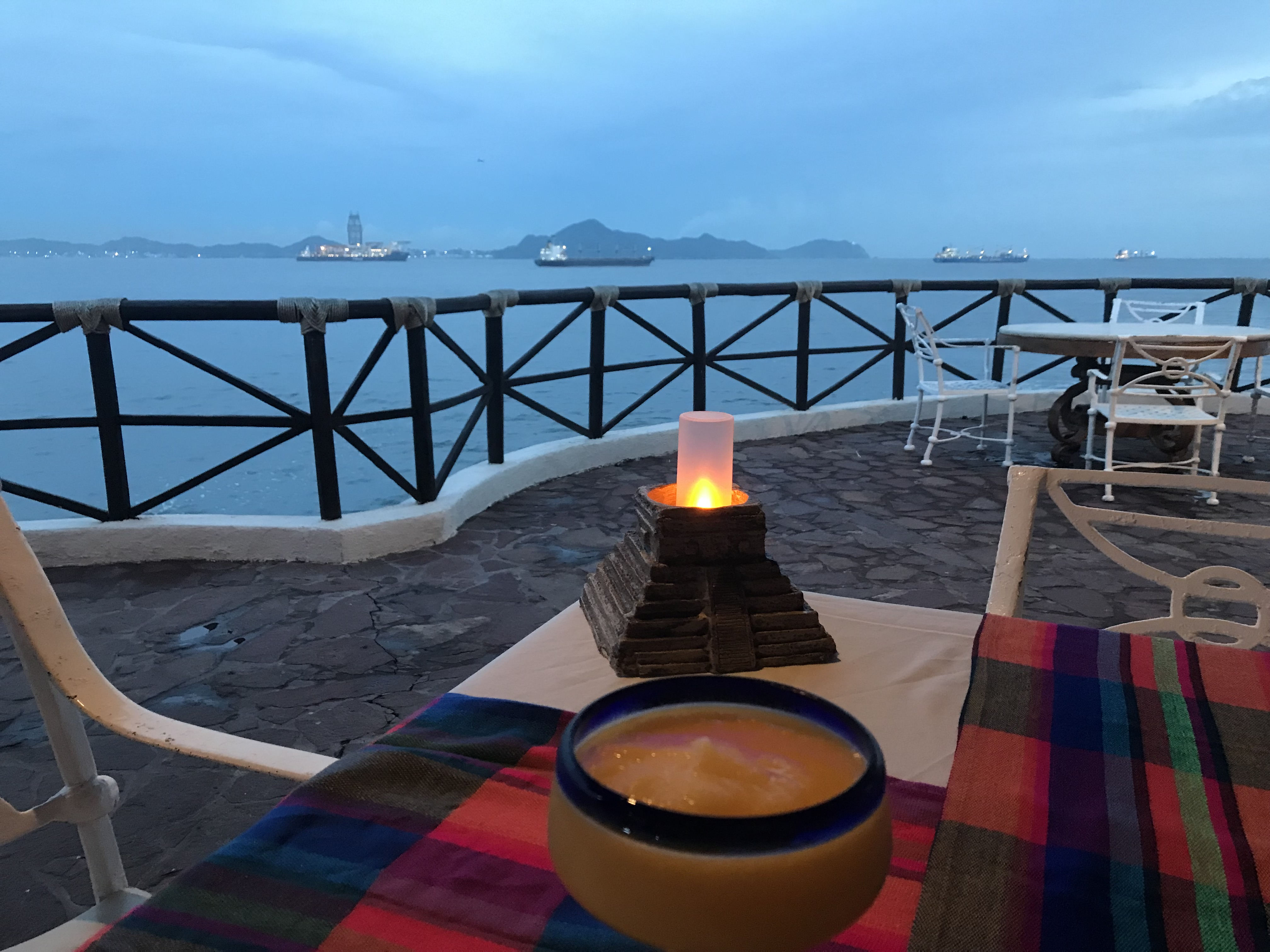
Per TMC’s latest update, the earliest that deepsea mining operations could be conducted is late 2025, so the vessel is likely to remain in Manzanillo for Andrew’s viewing pleasure. Nothing like a water view with a rig on the horizon. 😉
Andrew’s viewing location5X enlargement for a better look at the mining vessel.
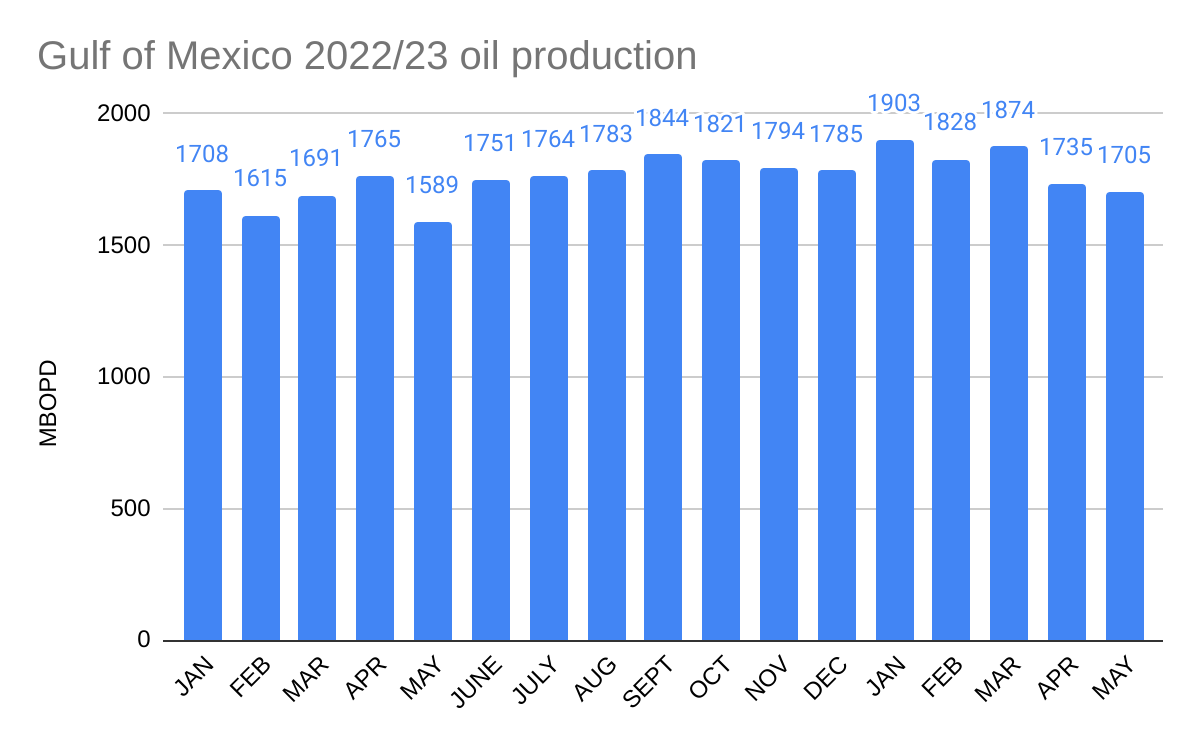
Gulf of Mexico 2023 oil production has dipped over the past 2 months, and is down 10% since January.
2023 production is reasonably well aligned with the EIA forecast which shows new production being offset by declines in existing fields.
Last year, BOEM forecast that production would average 2.0 million bopd in 2023. That forecast was justification for curtailing BOEM’s Proposed 5 Year Leasing Program. For the first time in the history of the OCS program, the primary concern of the program managers was that production might be too high for too long! This stunning quote from the 5 year leasing plan explains why so few lease sales were proposed:
“BOEM’s short-term (20-year) production forecast for existing leases shows steady growth from 2022 through 2024 and declining thereafter (see Section 5.2.1). The long-term nature of OCS oil and gas development, such that production on a lease can continue for decades makes consideration of future climate pathways relevant to the Secretary’s determinations with respect to how the OCS leasing program best meets the Nation’s energy needs.“
Per the DOI regulatory agenda published on 7/27/2023 (excerpt below), the final BSEE well control rule was published in June. Of course, that did not happen, but the update tells us that the final rule should be published soon. The delay is probably in the internal review process which moves at the pace of continental drift 😉.
BOE comments on the proposed rule are attached here.
12. Oil and Gas and Sulfur Operations in the Outer Continental Shelf-Blowout Preventer Systems and Well Control Revisions [1014–AA52]
Legal Authority: Not Yet Determined [BOE note: This is rather comical since the OCSLA authority was specified in the preamble to the proposed rule and you would never publicly imply that you didn’t know the authority for a final rule. 😉]
Abstract: This rulemaking revises the Bureau of Safety and Environmental Enforcement (BSEE) regulations published in the 2019 final rule entitled “Oil and Gas and Sulfur Operations in the Outer Continental Shelf-Blowout Preventer Systems and Well Control Revisions,” 84 FR 21908 (May 15, 2019), for drilling, workover, completion and decommissioning operations. In accordance with Executive Order (E.O.) 13990 (Protecting Public Health and the Environment and Restoring Science to Tackle the Climate Crisis) and the E.O.’s accompanying “President’s Fact Sheet: List of Agency Actions for Review,” BSEE reviewed the 2019 final rule and is updating to subpart G of 30 CFR part 250 to ensure operations are conducted safely and in an environmentally responsible manner.
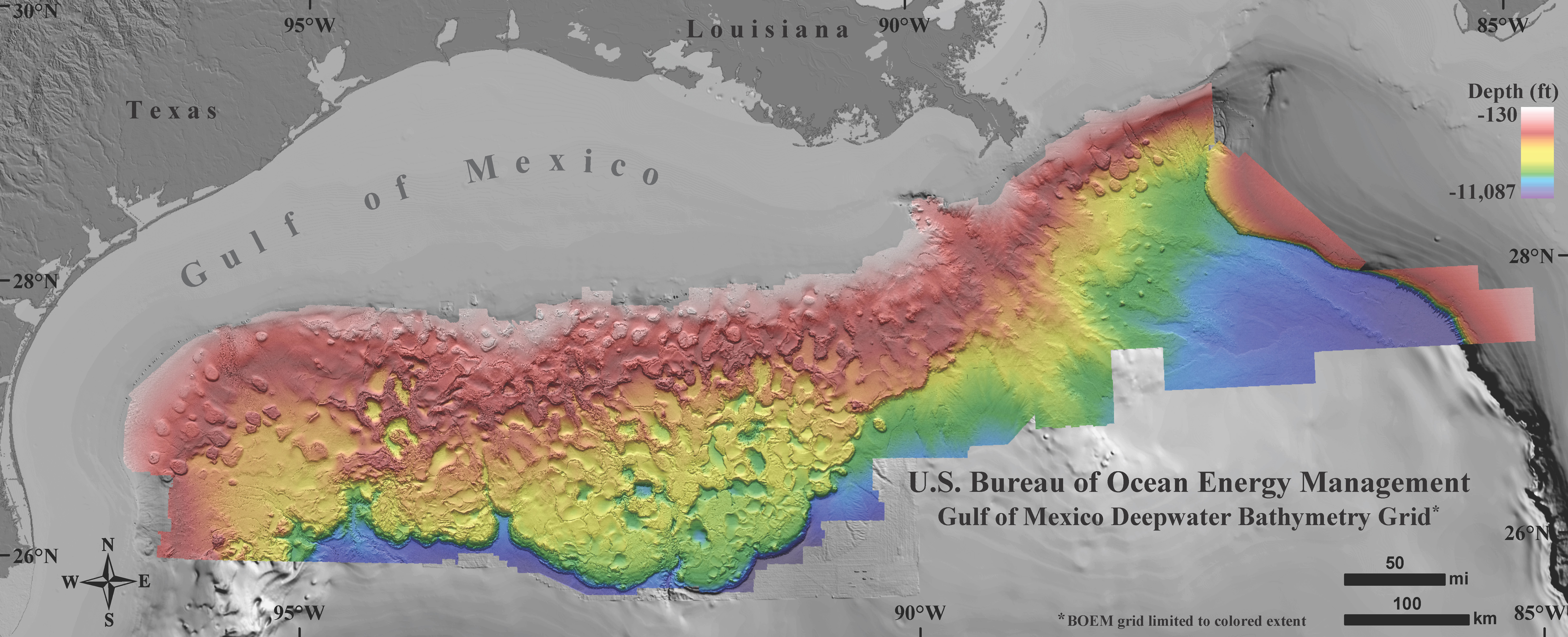
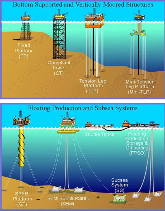
In the Gulf of Mexico, deepwater leases produce large volumes of oil and gas from only a few surface facilities that are relatively distant from shore.
The Gulf of Mexico encompasses approximately 617,800 square miles and stretches 932 miles across from east to west. BOEM’s deepwater bathymetry grid of the northern Gulf of Mexico, created using 3D seismic data, covers more than 90,000 square miles (colored area in figure below). In this vast area, only 59 surface facilities produce ~1.7 million bopd and 2.2 bcfd.
The 59 deepwater facilities are comprised of:
6 fixed platforms in water depths from 1023 to 1353′
2 compliant towers (1648 and 1754′)
17 tension leg platforms and mini-TLPs (1500-5185′)
18 spars (1930-7835′).
13 production semisubmersibles (aka floating production units; 3280-7400′)
2 fpso’s (8300 and 9560′) and a mobile production unit (2200′)
Attached is a settlement agreement between NOAA and 4 NGOs that could have major implications for deepwater oil and gas operations in the Gulf of Mexico.
As background, the Rice’s Whale (formerly Bryde’s whale) area has been expanded (see map above) such that it fences off deepwater leases by creating a barrier to vessel transportation. The expansion is based on a single study that concluded that Rice’s whales were “the most plausible explanation” for moan calls observed in the northwest GOM shelf break area. No Brice’s whales were sighted in the expanded area during this study. The authors do point to a 2017 sighting offshore Corpus Christi, which is apparently the only actual sighting of a Brice’s whale along the NW GoM shelf break.
The settlement agreement commits BOEM, presumably with their concurrence, to exclude the expanded area from future leasing, to issue a Notice to Lessees and Operators (exhibit 1 below) and to attach stipulations to new leases (exhibit 2). Because BOEM’s authority to impose major new requirements without proposing a regulation for public review and comment is questionable, the Notice (NTL) describes the restrictions as “recommended measures.” However, the liability risks associated with the failure to comply with this “guidance” would be unacceptable to most companies. Adding to the muddle, the language in the lease stipulation differs by making it perfectly clear that compliance is required.
The most troubling restriction from an operational standpoint:
“To the maximum extent practicable, lessees and operators should avoid transit through the Expanded Rice’s Whale Area after dusk and before dawn, and during other times of low visibility to further reduce the risk of vessel strike of Rice’s whales.“
Comments:
Deepwater facilities are typically far from shore, and a requirement to transit only between dusk and dawn, particularly in the winter, is unrealistic and onerous. This is further complicated by the speed limit provision.
Those who have worked offshore know that periods of low visibility are unpredictable and can extend for days. The low visibility transit restriction is thus highly punitive and increases operational risks on the vessels and at the facilities they serve.
The vague “to the maximum extent practicable” caveat provides little comfort for planners, managers, and crews, and is a de facto acknowledgement that the requirement is unreasonable.
These restrictions, coupled with the required Automatic Identification System data, open the door to endless challenges, especially given the keen interest of the litigious organizations that are parties in the settlement agreement.
Deepwater GoM operations are few in number and highly dispersed, which is a more important mitigating factor than those included in the agreement. More on this tomorrow.
In addition to the deepwater operations that will be much more difficult to supply, there are currently 81 production platforms within the expanded Rice’s whale area (100 to 400 m water depth).These include important facilities like Amberjack, Cognac, Cerveza, and Lobster. What are the implications for these platforms? Will they be required to have full-time whale observers? Can they only be supplied during daylight hours with good visibility? Why not consider using these platforms as bases for more definitive studies?
Further to the previous point, there are 103 existing leases in the 100-400 m depth zone that is now excluded from leasing? 90 of these leases are still in their primary term, and 21 were issued in the past 2 years. How will the contractual rights of these leaseholders be protected? (In fact, the value of all 1550 active leases in >100 m water depth is affected by this agreement.)
Have BSEE and Coast Guard been consulted on the practicality and safety implications of these requirements?
Deepwater operations have been ongoing in the GoM for 50 years, and there is no apparent evidence of impacts to this species. Why can’t the consultation process and any necessary followup studies be completed before decisions are made regarding operating restrictions?
Finally, BOEM’s third footnote in the NTL (pasted below), doesn’t demonstrate great confidence in the need for the onerous requirements that are being imposed.
“This is not meant to be construed as a blanket determination as to whether BOEM, at present, has determined that there is a “reason to believe” that incidental take may occur, within the meaning of the ESA, the consultation regulations, or BOEM’s regulations. Those decisions will be made on a case-by-case basis in accordance with BOEM regulations referenced below.” Comment: Huh??? How are these blanket restrictions case-by-case, and how are they being imposed without public review?
Jean-Louis Daeschler, a pioneering offshore engineer, has shared this very interesting story about his interaction with George HW Bush (pictured):
One day I was driving in Kennebunkport and told my wife that I met the man who lived in that house on the coastal road – the President George HW Bush!
Early in my career, a new drillship was being built in Port Arthur TX for Zapata Offshore. One morning, the entrance to the shipyard was closed off. A peaceful group of picketers told us we could not enter. Many of us had left work clothes, file drawings, and even passports and money at our camp in the yard. This was before mobile phones and the internet! So we went back home to wait for guidance. 2-3 days later we had to attend a meeting in Houston (a 2 hr drive) at the Pennzoil Tower, and we met Mr Bush. He was very cool and calmed us down. He advised us not to cross the picket line or get into an argument with the workers. He had already made arrangements to use 4-5 rooms at a Holiday Inn near Beaumont. They removed the hotel furniture and provided desks, pencils, and phones. Our personal effects had been collected from the yard and delivered to the our temporary workplace at the Holiday Inn.
My colleagues and I had a great chat with Mr. Bush. In particular he asked me questions about the D-Day invasion at Normandy. However, although I was born there, it was at the end of the war in 1945, so I did not personally experience the invasion. We left the meeting relaxed and with directives on what not to do. He kindly gave me one of his gold Cross pens, before we shook hands and departed.
Years later at a dinner in Aberdeen with Total Fina Elf, I gave that pen to the wife of the Project Manager (without the story). So there we go; a pen from Houston goes to Paris via Aberdeen in 17 years! Sometimes you smile in the oil patch!
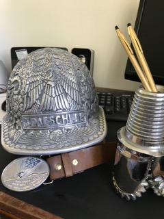
JL Daeschler photo: Red Adair belt with a diamond drill bit from the Beaufort sea, a hardhat from Indonesia, and 2 new Cross pens! Life is good 😀
This wonderful satellite image of Cape Cod, Nantucket, and Martha’s Vineyard was posted by a Facebook friend. Cape Cod is quite young, having been formed by a retreating glacier about 20,000 years ago.
I moved to Cape Cod 43 years ago in preparation for the exploratory drilling operations on Georges Bank. I met so many amazing and supportive people during my 4 years there including (most importantly) my wife, State and local officials, congressional representatives, Woods Hole scientists, fishermen, reporters, airport officials, industry representatives, Coast Guard officers, offshore workers, environmental activists, and concerned citizens. All contributed to an outstanding work experience for me and my colleagues.
The 8 exploratory were at locations 112 to 155 miles SE of Nantucket (map below).
I lived in Hyannis, not far from the Kennedy compound (pictured below) which was on my jogging route. It was an easy bike ride to our office at Barnstable Municipal Airport, where we departed to inspect the exploratory drilling operations.
RFK Jr. talks about the Kennedy compound and the “Camelot years” during JFK’s presidency.
The final NTSB report on the 12/29/2022 GoM helicopter crashthat killed 4.To the NTSB’s credit, their preliminary report was timely. Hopefully, the NTSB is considering the muddled regulatory regime for helidecks (regulatory fragmentation).
Report on the Nord Stream sabotage: As the anniversary nears, the prospects for an official report are fading.The absence of a report from Sweden, Denmark, or Germany speaks volumes.
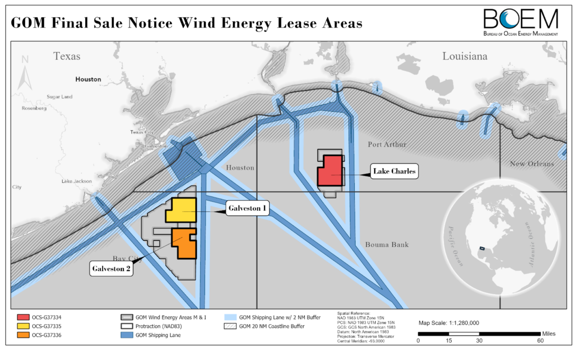
BOEM’s Final Sale Notice for the upcoming Gulf of Mexico wind auction identifies 3 lease areas (see map below). Wind operations in these areas should not significantly conflict with other GoM activities, including oil and gas operations.
Those who followed Exxon’s recent lease acquisitions may be amused by the map below from BOEM’s siting analysis document. The 94 Exxon leases acquired at Oil and Gas Lease Sale 257 (yellow blocks) are misidentified as “Carbon Capture Lease Blocks.” As has been discussed at length on this blog (most recently here), Sales 257 and 259 were oil and gas lease sales. Although Exxon’s intentions are now well known, they may not conduct carbon sequestration operations on these leases unless they are competitively reissued or converted. (Is BOEM’s siting document implying that conversion of the Exxon leases is a fait accompli?) The regulations for such conversions, and for CCS operational activities, have yet to be promulgated. A draft of these regulations is expected later this year, and the comments should be spirited and diverse.