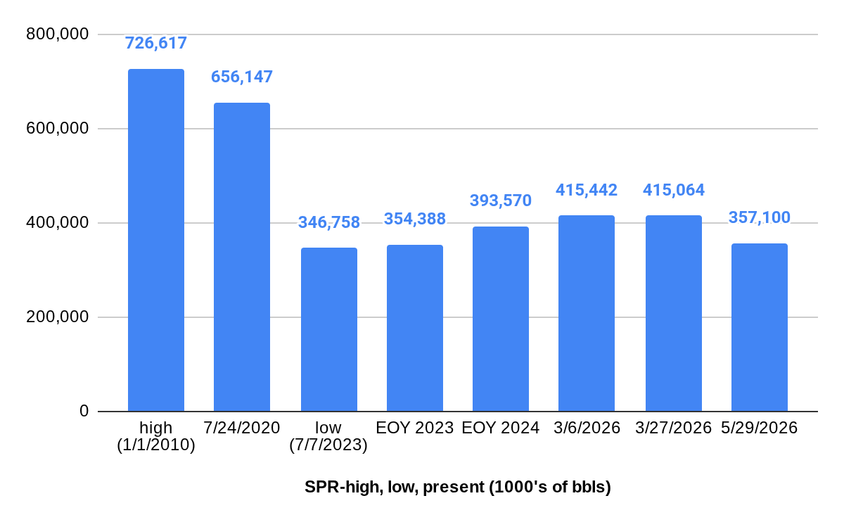
Nothing tilts public opinion more than high gasoline prices, or worse yet shortages! Hence the 1975 legislation establishing the SPR, the massive SPR drawdown in 2022, and this year’s withdrawals.
Looking back to the halcyon days of the US offshore program, it was the gas lines in the 1970s that drove the remarkable and rather unlikely growth in the program during the Carter Administration (1977-1981). A few highlights from those four years:
15 lease sales including 3 offshore Alaska, 3 in the Atlantic, and 1 offshore California
Drilling activity in all 4 regions: GoM, Pacific, Alaska, and Atlantic
North, Mid, and South Atlantic District offices for permitting and inspections
5300 well starts including 97 in water depths > 1000′
314 new platforms including Cognac, the world’s first platform in > 1000′ of water
Perhaps unthinkable today, the Governor of Massachusetts from 1979-1983, Ed King, was a strong supporter of offshore drilling. Absent that support, the exploratory drilling on Georges Bank would probably have never occurred. /s/ Nostalgic Old Man 😉
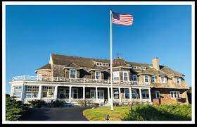
In 1980, Don Kash, the great leader who was Chief of the Conservation Div. of USGS (the current equivalent of the Conservation Div. is BSEE plus the resource evaluation functions in BOEM plus some royalty management functions now in ONRR) asked me to move to Cape Cod to head a new office responsible for overseeing exploratory drilling operations on Georges Bank. We established a small office in an old maintenance building at Barnstable Municipal Airport in Hyannis. The space was decidedly unglamorous but functional and ideal for helicopter transit to the offshore rigs.
Karen was a Cape Cod artist and art teacher at Nauset Middle School in Orleans (for baseball lovers, that is where the Orleans Firebirds of the famous Cape Cod League play). Some of her teacher friends were connected to a running club I belonged to, and unknown to me at the time, Karen had designed my beloved Provincetown Dunes Run t-shirt.
We had another connection in that we had bought condominiums built by the same company. Hers was in Orleans and mine was in Hyannis. A couple that owned a condo in each project got to know both of us and thankfully introduced us. A year and many great experiences later we were married at the historic Captain Linnell House in Orleans.
Interestingly, Karen’s mother was an opponent of Georges Bank drilling until she realized that her only daughter would be leaving Cape Cod when the drilling ended. She then changed her position, proving once again that all politics is local 😀
I was very lucky to have spent 4 challenging and exciting years on Cape Cod. The Georges Bank drilling story was uniquely remarkable for me and led to a daughter born at my next duty station (Santa Maria, CA) and 5 grandchildren (good ratio 😀). While I was particularly fortunate, I think the Georges Bank drilling experience was generally positive for all that participated including the State and local officials, Woods Hole scientists, media, industry personnel, commercial fishermen, and even the Greenpeace protesters who were on the scene 155 miles southeast of Nantucket!
This impressive NOAA study confirms the importance of Nantucket Shoals as a feeding ground for right whales and implies a need for protective measures in months (October through December) when the existing restrictions do not apply.
“The importance of Nantucket Shoals as a feeding ground for the critically endangered North Atlantic right whales within the southern New England wind energy is well understood (Leiter et al., 2017; Quintana-Rizzo et al., 2021; Estabrook et al., 2022). Similarly, year round presence of this species has been demonstrated since as early as 2011 (Quintana-Rizzo et al., 2021; Estabrook et al., 2022), showing that North Atlantic right whales have consistently used this region for well over a decade. Currently, the National Marine Fisheries Services and Bureau of Ocean Energy Managements policy is to exclude pile driving during the months of January through April in the southern New England wind energy area. Evaluation of the need for further management protections are needed for North Atlantic right whales especially in October through December, along with further assessment of risk to this species (Southall et al., 2023).
A map of the southern New England planned offshore wind energy lease areas off the East Coast of the United States (insert). Passive acoustic recorders (SoundTrap and F-POD recorders) were deployed for varying time periods (see Table 1) between January 2020 and November 2022 at seven sites surrounding the wind energy areas.
Note (below) the acoustic presence of the North Atlantic Right Whale (NARW) from Oct. through April.
Weekly acoustic presence summary of eight cetacean species (harbour porpoise, sperm whale, humpback whale, minke whale, North Atlantic right whale (NARW), sei whale, fin whale, blue whale) and one family (Delphinid sp.). The boxplots represent the median number of days of acoustic presence per calendar week across all data at four recording sites, in the southern New England offshore wind energy area. Only recorders with 2 or more years of data (NS01, NS02, COX01, and COX02) were used. Horizontal lines within the boxes indicate the median, box boundaries indicate the 25th (lower quartile) and 75th (upper quartile) percentiles, vertical lines indicate the largest (upper whisker) and smallest (lower whisker) values no further than 1.5 times the interquartile range, and black dots represent outliers.
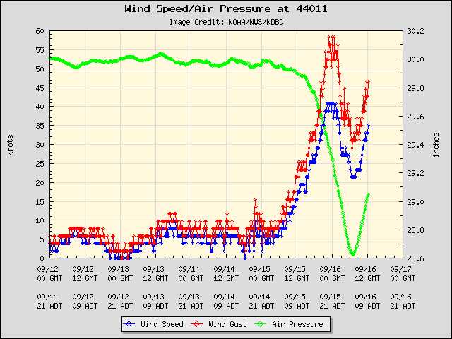
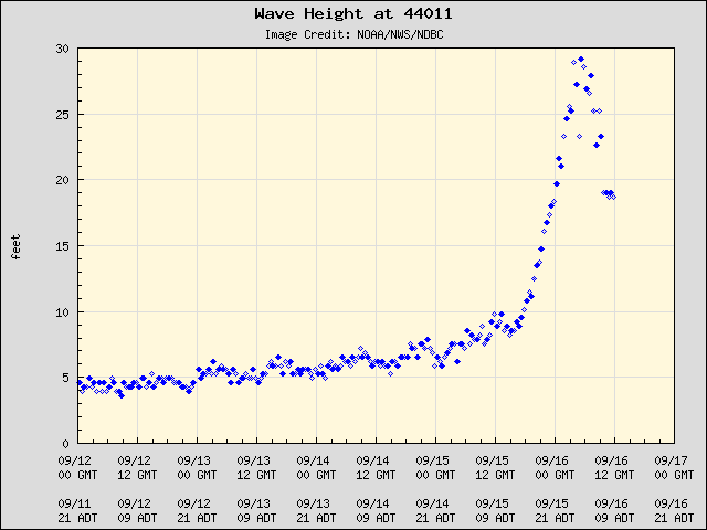
The worst conditions were relatively common by Georges Bank standards. Per the NOAA data buoy (see plots below), the wind speed peaked at 40.8 kts, gusts at 58.3 kts, and wave height at 29.2 ft.
Looking back at my Georges Bank Exploratory Drilling paper (1983), a spring storm in April 1982 generated 105 mph winds and 35 foot swells. I’ll post information on the rig performance issues during those operations at a later date.
This is an excellent tribute written by two brothers who lost their father in the Ocean Ranger tragedy. I highly recommend that you listen and reflect.
Condensed below is important background information from my notes and from an outstanding presentation by Howard Pike in St. John’s Newfoundland in 2017.
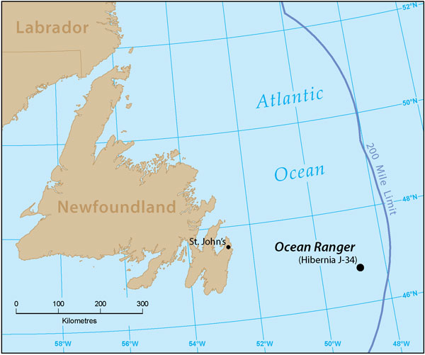
84 men aboard; no survivors
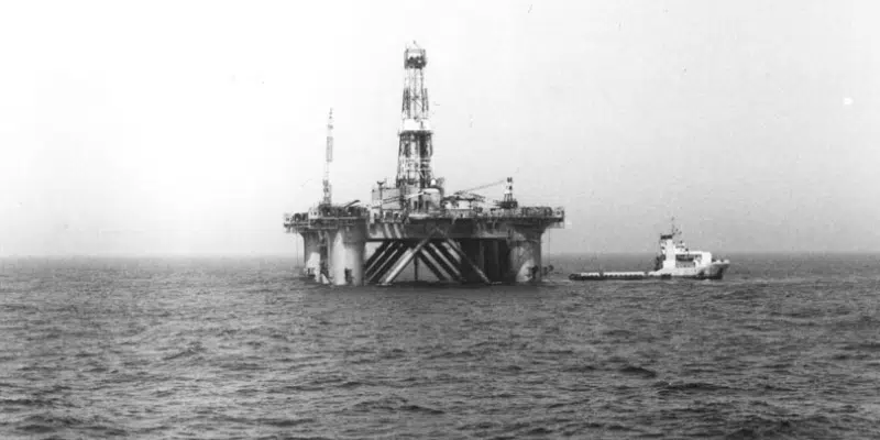
Largest semisubmersible drilling rig of its day
US registered MODU
The “unsinkable” rig had weathered more than 50 significant storms
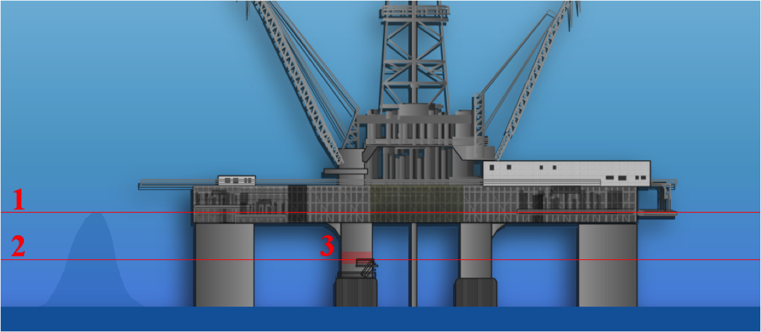
Unlike most semisubmersibles, the ballast control room was located in one of the legs (starboard column No.3). At drilling draft, it was just 28 feet above mean sea level.
Water depth was 240′, rig was moored with 12 anchors
Ballast control operators had minimal training
Incident with the ballast control system just a week before the disaster.
On February 14th, the Ocean Ranger was battered by a severe storm; wave heights up to 21m; rogue wave damaged deck items on nearby Sedco 706
Crew stopped drilling when the heave exceeded 15′, forced to shear the drill pipe during the disconnect process
Crew did not deballast to the storm draft from the 80′ drilling draft
Waves broke portlight in the ballast control room
Salt water soaked the ballast control console
Short circuits or inadvertent operator commands caused ballast tank valves in the bow to open.
Water flooded the forward ballast tanks, and the rig began to list toward the bow.
Crew inadvertently opened more pontoon valves
Forward list passed the point of recovery
The Ranger’s standby vessel, the Seaforth Highlander, was contacted but was delayed by sea conditions
At approximately 1:10 a.m. on February 15 th , the Ocean Ranger began sending mayday signals.
Zapata Ugland and Sedco 706, working in the area, sent their standby vessels
At 1:30 a.m. the Ocean Ranger’s radio man sent his final transmission. The crew was boarding the lifeboats.
Investigators later determined that as the lifeboats descended, violent winds threw them against the side of the rig, damaging some lifeboat hulls before they ever touched the water.
Crew did not have survival suits
Seaforth Highlander attempted unsuccessfully to rescue survivors from a damaged lifeboat
At the time of the Ocean Ranger tragedy, 3 rigs – the Alaskan Star, Rowan Midland, and Zapata Saratoga were working on Georges Bank in the US North Atlantic. The nor’easter had passed over Georges Bank before strengthening as it moved toward the Grand Banks. Among the small Georges Bank drilling community there was a kinship with those working in the even harsher environment on the Grand Banks. 40 years later, we are still greatly saddened by what transpired. Many lessons were learned and applied, but the ocean is unforgiving and we must continue to assess storm preparedness. Reflection on past tragedies is an important part of the process.
I was saddened to learn that the National Academy of Sciences is selling the Jonsson Center in Woods Hole, MA. This amazing meeting and conference facility is at a great waterfront location at the epicenter of marine research on the Atlantic Coast. You can buy the estate for a mere $27.5 million and continue its use as a conference center serving the marine science and policy communities.
“I think the concern is this is a historically important location for science, from its long history with the institutions,” said Dr. Saito. “To see one of our science institutions pack up and leave is sad for the community. Also, the loss of that conference facility, which I think is a really valuable resource for not just the area but for US science, is a sad thing to see happen as well.”
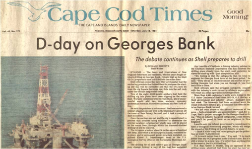
40 years ago today, drilling began on the first two exploratory wells on Georges Bank, a large seafloor feature that separates the Gulf of Maine from the Atlantic Ocean. The Cape Cod Times headline (below) attests to the drama that was unfolding 155 miles southeast of Nantucket. After years of debate, oil embargoes, gas lines, and the threat of future supply disruptions had tipped the political balance in favor of offshore leasing, and OCS Sale No. 42 (North Atlantic) was held one week before Christmas in 1979. Looking back, I find it remarkable that only 19 months elapsed between the lease sale and the initiation of drilling. During that time, bids were evaluated, exploration and spill response plans were drafted by the operating companies and reviewed by the Federal regulators and six coastal states, fisheries issues were addressed, and a comprehensive monitoring program was developed and initiated. Perhaps most impressive was the manner in which government (Federal and State), industry, and academic professionals with very different personal opinions about offshore drilling collaborated to assess and monitor impacts and mitigate risks.
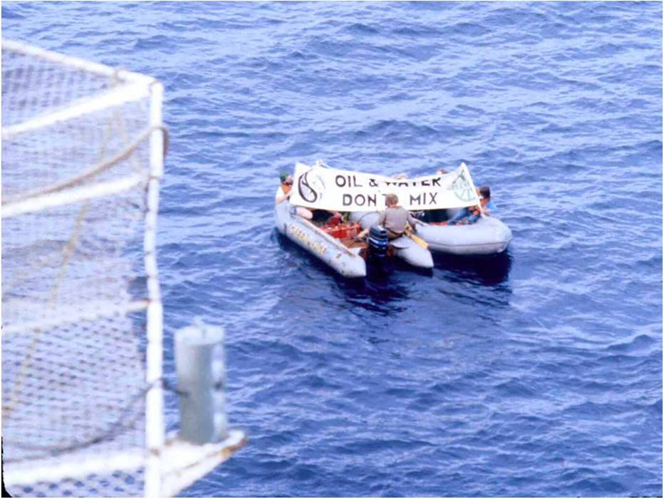
The protesters pictured above were dispatched to the Zapata Saratoga drilling rig from the Greenpeace vessel Rainbow Warrior. Given the remote location, the protest was unexpected. However, the drilling operation was not disrupted and no action was taken against the protesters. Four years later, the Rainbow Warrior was bombed by French commandos while in port in Auckland, NZ prior to planned protests against French nuclear testing in the South Pacific. Sadly, one crew member was killed during this incident.
Below is a list of the exploratory wells that were drilled on Georges Bank. In addition, two off-structure geologic test wells were drilled in 1976 and 1977. None of the wells discovered commercially significant oil and gas resources. However, gas shows led to erroneous press reports such as the article below. In 2000, the Minerals Management Service (MMS) published a summary of the geologic findings.
Operator Lease No. Block/Well Rig ___________
Water Depth (ft.)
_________
Lat/Long Miles SE Nantucket ____________
Onsite
__________
Spud
________
Offsite
_________
Well Depth (ft. ) ________
Exxon 0170 133/1 Alaskan Star
225
40°49’05” 67°56’03” 112
7/22/81
7/24/81
11/24/81
13,808
Shell 0218 410/1 410/1R Saratoga
452
40°34’24” 67°12’32” 155
7/10/81 8/8/81
7/24/81 8/10/81
8/8/81 3/31/82
875 15,043
Mobil 0200 312/1 Midland
260
40°39’27” 67°45’55” 125
11/21/81
12/8/81
6/27/82
19,652
Exxon 0153 975/1 Alaskan Star
209
41°00’24” 67°37’19” 125
11/24/81
11/25/81
3/10/82
14,313
Tenneco 0182 187/1 Alaskan Star
300
40°46’15” 67°23’19” 140
3/10/82
3/12/82
8/22/82
17,744
Shell 0210 357/1 Saratoga
265
40°36’51” 67°44’41″1 128
4/2/82
4/14/82
9/27/82
19,090
Conoco 0179 145/1 Aleutian Key
300
40°49’59” 67°17’06” 145
5/9/82
5/13/82
8/25/82
14,115
Mobil 0196 273/1 Midland
302
40°41’04” 67°30’12” 140
6/28/82
6/30/82
9/13/82
15,190
Excerpted from “Georges Bank Exploratory Drilling, 1981-1982” by EP Danenberger
Regulatory policy lessons from the Georges Bank experience:
Regulators with overlapping responsibilities function best as a joint authority, particularly at the field level. While MOUs/MOAs tend to be primarily for the purpose of protecting regulatory turf, joint authorities focus on the specific mission and how the performance objectives they can best be achieved. Capt. Barry Eldridge had the foresight to co-locate a USCG Marine Safety Detachment, headed by Bob Pond, adjacent to the USGS office at Barnstable Municipal Airport. This facilitated cooperative reviews, coordinated inspections, and joint exercises. This collaboration led to the first ever unannounced offshore response drills. Similar USCG/DOI organizational arrangements have proven effective in the Pacific and in the Gulf of Mexico, particularly for monitoring hurricane preparations and responses.
Strive to conduct regulatory functions at a single field office. USGS had the foresight to assign exploration plan review, environmental assessment, and coordination with State government responsibilities to our district office. As a result, our environmental specialists, geologists, engineers, and inspectors worked together, along with our State and Federal partners, from the initial planning to the decommissioning stages. Positive working relations were developed and everyone was informed and involved. A subsequent reorganization changed the structure of our office and led to greater control from Washington, which (unsurprisingly) was not helpful.
Transparency may be a bit of a buzzword, but it’s critical to regulatory success. Other than proprietary geologic information and well reports, we fully informed our regulatory partners about the status of activities, all incidents and near-misses, and any operational issues. Conveying news that is not-so-good, like the mooring failures that were experienced by 2 Georges Bank rigs, is part of the mission.
Those regulating the operations should be informed about and a part of the environmental monitoring programs. Our office worked closely with the Woods Hole and other scientist conducting the comprehensive Georges Bank Monitoring Program. In support of Mike Bothner, USGS Woods Hole scientist, we tracked every drilling fluid additive, and verified the materials that were available on each rig. Mike conducted a material balance on the barite and looked for chromium and other metals in sediments near the well sites. His outstanding work is summarized in this paper.