….for continuing to recognize the Conservation Division of the Geological Survey (USGS) as the US offshore safety regulator, even though 40 years have passed since that was the case and there have been 3 successor bureaus. 😀
(a) Design and equipment requirements of this subchapter for OCS facilities, including mobile offshore drilling units in contact with the seabed of the OCS for exploration or exploitation of subsea resources, are in addition to the regulations and orders of theU.S. Geological Survey applicable to those facilities.
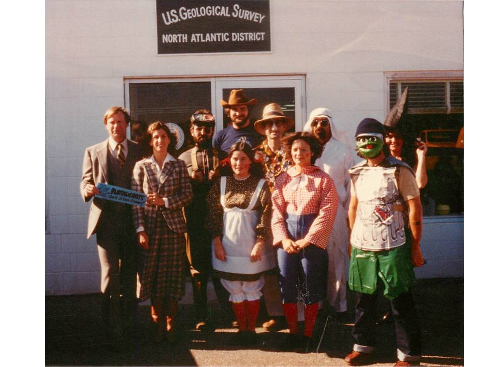
USGS North Atlantic District, Hyannis, MA, Halloween 1980
Most of us old-timers think the best regulatory framework for the offshore program was in the USGS days (pre-1982). Some of this may be nostalgia, but there are some good reasons for this thinking:
USGS was/is an internationally acclaimed scientific organization that was always headed by a renowned geologist. The regulatory program was thus somewhat insulated from political pressures. Vince McKelvey, Bill Menard, and Dallas Peck were the Directors when I worked for USGS. Their credentials are linked. Bill and Dallas visited our Hyannis office (not at Halloween 😀) and were very supportive.
The Conservation Division was responsible for onshore operations on Federal lands as well as offshore activity. This facilitated information sharing and offered diverse career opportunities. My first bosses in New Orleans had worked previously in the Farmington and Roswell, NM offices.
We had excellent synergy with the other USGS divisions. The Marine Science Center in Woods Hole was an incredible resource for our Hyannis office. The Woods Hole office, particularly Mike Bothner and Brad Butman, had a critical role in the Georges Bank Monitoring Program, the best ever (in my biased opinion) environmental study of exploratory drilling operations in a frontier area.
The USGS Conservation Division had a very small and supportive headquarter’s staff, which minimized the potential for conflict with field offices.
Prior to the formation of the Minerals Management Service (MMS) in 1982, the Bureau of Land Management was responsible for leasing, but all regulatory functions were under USGS. This included resource evaluation/conservation, plan review and approval, permitting, inspections and enforcement, and investigations. The division of MMS responsibilities, most notably the assignment of plan approval to the leasing bureau (BOEM) rather than the regulatory bureau (BSEE), complicates the work of both bureaus and is a prescription for inefficiency, confusion, overlap, and conflict.
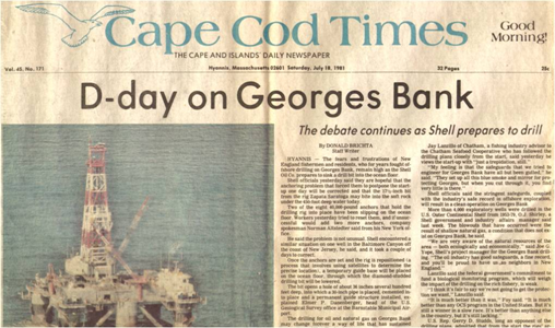
40 years ago today, drilling began on the first two exploratory wells on Georges Bank, a large seafloor feature that separates the Gulf of Maine from the Atlantic Ocean. The Cape Cod Times headline (below) attests to the drama that was unfolding 155 miles southeast of Nantucket. After years of debate, oil embargoes, gas lines, and the threat of future supply disruptions had tipped the political balance in favor of offshore leasing, and OCS Sale No. 42 (North Atlantic) was held one week before Christmas in 1979. Looking back, I find it remarkable that only 19 months elapsed between the lease sale and the initiation of drilling. During that time, bids were evaluated, exploration and spill response plans were drafted by the operating companies and reviewed by the Federal regulators and six coastal states, fisheries issues were addressed, and a comprehensive monitoring program was developed and initiated. Perhaps most impressive was the manner in which government (Federal and State), industry, and academic professionals with very different personal opinions about offshore drilling collaborated to assess and monitor impacts and mitigate risks.
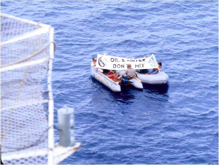
The protesters pictured above were dispatched to the Zapata Saratoga drilling rig from the Greenpeace vessel Rainbow Warrior. Given the remote location, the protest was unexpected. However, the drilling operation was not disrupted and no action was taken against the protesters. Four years later, the Rainbow Warrior was bombed by French commandos while in port in Auckland, NZ prior to planned protests against French nuclear testing in the South Pacific. Sadly, one crew member was killed during this incident.
Below is a list of the exploratory wells that were drilled on Georges Bank. In addition, two off-structure geologic test wells were drilled in 1976 and 1977. None of the wells discovered commercially significant oil and gas resources. However, gas shows led to erroneous press reports such as the article below. In 2000, the Minerals Management Service (MMS) published a summary of the geologic findings.
Operator Lease No. Block/Well Rig ___________
Water Depth (ft.)
_________
Lat/Long Miles SE Nantucket ____________
Onsite
__________
Spud
________
Offsite
_________
Well Depth (ft. ) ________
Exxon 0170 133/1 Alaskan Star
225
40°49’05” 67°56’03” 112
7/22/81
7/24/81
11/24/81
13,808
Shell 0218 410/1 410/1R Saratoga
452
40°34’24” 67°12’32” 155
7/10/81 8/8/81
7/24/81 8/10/81
8/8/81 3/31/82
875 15,043
Mobil 0200 312/1 Midland
260
40°39’27” 67°45’55” 125
11/21/81
12/8/81
6/27/82
19,652
Exxon 0153 975/1 Alaskan Star
209
41°00’24” 67°37’19” 125
11/24/81
11/25/81
3/10/82
14,313
Tenneco 0182 187/1 Alaskan Star
300
40°46’15” 67°23’19” 140
3/10/82
3/12/82
8/22/82
17,744
Shell 0210 357/1 Saratoga
265
40°36’51” 67°44’41″1 128
4/2/82
4/14/82
9/27/82
19,090
Conoco 0179 145/1 Aleutian Key
300
40°49’59” 67°17’06” 145
5/9/82
5/13/82
8/25/82
14,115
Mobil 0196 273/1 Midland
302
40°41’04” 67°30’12” 140
6/28/82
6/30/82
9/13/82
15,190
Excerpted from “Georges Bank Exploratory Drilling, 1981-1982” by EP Danenberger
Regulatory policy lessons from the Georges Bank experience:
Regulators with overlapping responsibilities function best as a joint authority, particularly at the field level. While MOUs/MOAs tend to be primarily for the purpose of protecting regulatory turf, joint authorities focus on the specific mission and how the performance objectives they can best be achieved. Capt. Barry Eldridge had the foresight to co-locate a USCG Marine Safety Detachment, headed by Bob Pond, adjacent to the USGS office at Barnstable Municipal Airport. This facilitated cooperative reviews, coordinated inspections, and joint exercises. This collaboration led to the first ever unannounced offshore response drills. Similar USCG/DOI organizational arrangements have proven effective in the Pacific and in the Gulf of Mexico, particularly for monitoring hurricane preparations and responses.
Strive to conduct regulatory functions at a single field office. USGS had the foresight to assign exploration plan review, environmental assessment, and coordination with State government responsibilities to our district office. As a result, our environmental specialists, geologists, engineers, and inspectors worked together, along with our State and Federal partners, from the initial planning to the decommissioning stages. Positive working relations were developed and everyone was informed and involved. A subsequent reorganization changed the structure of our office and led to greater control from Washington, which (unsurprisingly) was not helpful.
Transparency may be a bit of a buzzword, but it’s critical to regulatory success. Other than proprietary geologic information and well reports, we fully informed our regulatory partners about the status of activities, all incidents and near-misses, and any operational issues. Conveying news that is not-so-good, like the mooring failures that were experienced by 2 Georges Bank rigs, is part of the mission.
Those regulating the operations should be informed about and a part of the environmental monitoring programs. Our office worked closely with the Woods Hole and other scientist conducting the comprehensive Georges Bank Monitoring Program. In support of Mike Bothner, USGS Woods Hole scientist, we tracked every drilling fluid additive, and verified the materials that were available on each rig. Mike conducted a material balance on the barite and looked for chromium and other metals in sediments near the well sites. His outstanding work is summarized in this paper.